

These are rolling updates on Hurricane Ian. The most recent update is located at the top of the article.
5:00 p.m. – Thursday, September 29, 2022
Ian is a hurricane again with winds at 75 mph. It is tracking NNE at 10 mph and is expected to make landfall near the Charleston/ Myrtle Beach area tomorrow afternoon around 2 pm.

Kemp, Emergency Management Officials Provide Update on Tropical Storm Ian Preparations
11:00 a.m. - Thursday, September 29, 2022
Tropical storm Ian is moving into the Atlantic and according to the NWS is likely to strengthen to a minimal hurricane before making landfall in South Carolina Friday. (see first image below). We can still expect the possibility of TS force wind gusts tonight and into Friday. Rain is expected in the range of 1-3 inches. Below is the latest.

5:00 A.M., Thursday, September 29, 2022
The 5 AM information on Ian has it still over Florida and it has been downgraded to a tropical storm with winds gusts at 65 mph. It is moving NE at 8 mph. The current path and timing indicate it will move into the Atlantic today and tracking NNW over the next 24 hours. Hopefully, it will remain just a TS before making landfall on the South Caroling coast Friday afternoon. We remain under a tropical storm watch and while the projected path has shifted a little more east, we should still stay prepared for the possibility of winds gusts of tropical storm force strength and rain between 2-4 inches.
5:00 P.M. Wednesday, September 28, 2022
The 5 pm update on Cat 4 Ian has it making landfall in SW Florida’s Lee County. Tonight, Ian will cross Florida very slowly. It is currently moving NNE at only 8 mph. Tomorrow it will emerge into the Atlantic and could gain some strength but is expected to remain at least a tropical storm before it makes landfall again north of Savannah and south of Charleston. We can expect tropical storm force winds beginning tomorrow afternoon and continuing through Friday with the possibility of 4-6 inches of rain. There is still some uncertainty on how the Atlantic may affect Ian so stay informed and safe.
4:00 P.M. Tuesday, September 27, 2022
Kemp Declares State of Emergency Ahead of Hurricane Ian
8:00 A.M. Tuesday, September 27, 2022


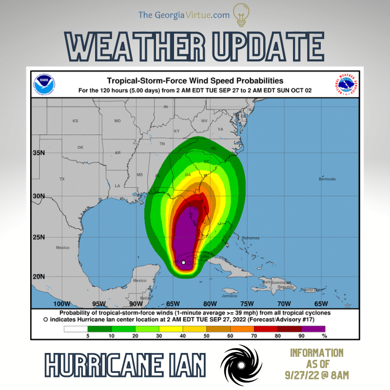
🌀Hurricane Ian 🌀is now a Cat 3 hurricane with maximum winds at 125 MPH with higher gusts.
- It is still expected to increase to a Cat 4. At 8AM, the storm was ~10 miles off the coast of Cuba. A reduction in strength is not expected as Ian moves across Cuba and up the western side of Florida on Wednesday.
- ☔Heavy rainfall is expected to affect the southeastern US beginning Thursday morning and continuing through Saturday. 4-6 inches is the current prediction.
- 🌨️Hurricane-force winds extend outward up to 35 miles from the center and tropical-storm-force winds extend outward up to 115 miles.
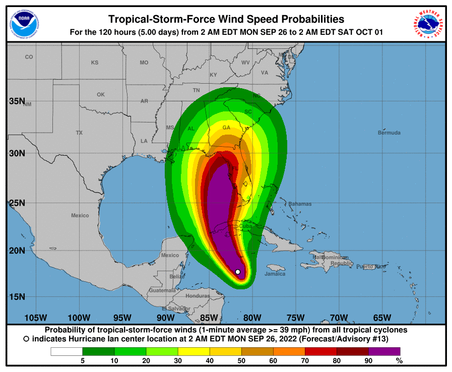
5:00 A.M. on Monday, September 26, 2022

- The Nat'l Hurricane Center has Ian at a 🌀Cat 1 Hurricane🌀 with maximum winds at 75 MPH with higher gusts.
- Ian is moving to the NW at 14 MPH and is expected to rapidly intensify to a Cat 4 storm in the Gulf of Mexico when it hits Cuba.
- It will experience some wind sheer as it approaches the Florida coast. A turn toward the north-northwest is expected today followed by a northward motion on Tuesday with a slightly slower forward speed.
- Remember that Hurricane-force winds extend outward up to 15 miles from the center and tropical-storm-force winds extend outward up to 90 miles.
- 🌨️We can expect winds to pick up beginning Thursday, Friday, and perhaps continuing into Saturday.
- ☔Heavy bands of rainfall are expected also.
Sunday, September 25, 2022
Kemp, Emergency Management Officials to Activate State Operations Center Monday


